Land Surveying And Essence of Topographical Survey
Land Surveying And Essence of Topographical Survey
Land Surveying And Essence of Topographical Survey
Topographic surveys epitomize the synergy between scientific rigor and practical application in land surveying. Through meticulous data collection, advanced technologies, and intricate calculations, these surveys unravel terrain complexities, empowering engineers, architects, and developers to make informed decisions. Land Surveying And Essence of Topographical Survey
Introduction of Land Surveying
Land surveying is a time-honored profession that marries the precision of science with the artistry of understanding landscapes. Among the various surveying techniques, topographic surveying stands out as a fundamental method for comprehensively capturing the intricate details of terrain. This article delves into the essence of topographic surveys, elucidating their significance, methodologies, and the intricate calculations involved.
Related Post
Introduction And Calculation Of Elevation With Rise Fall Method With Step
Surveying And Principles of Surveying In Civil Engineering
What Are The Traverse |Types Of Traverse And Method Of Traversing
What Is The Cut Fill And Method to Calculate The Cut And Fill
How to Calculate Distance and Bearing between Coordinates
What is the Topographic Survey
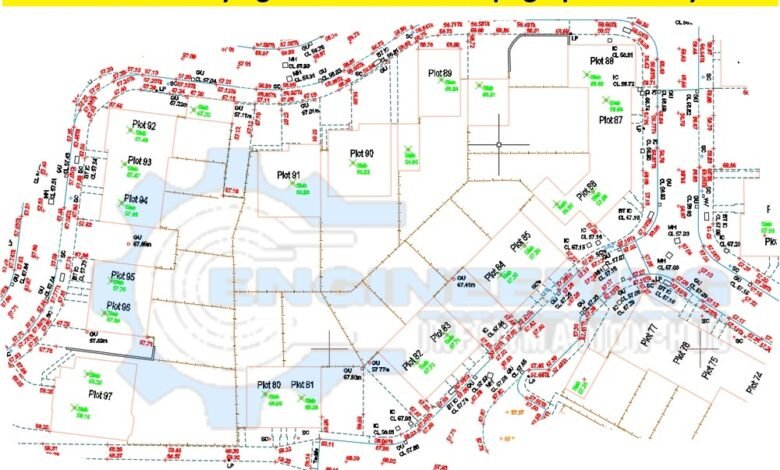
Topographic surveys entail the meticulous measurement and mapping of the natural and artificial features of land parcels. These surveys provide a detailed representation of the terrain’s elevation, contours, vegetation, structures, utilities, and other significant elements. By delineating these features, topographic surveys serve as the foundation for various engineering, architectural, and land development projects.
Method of Topographic Survey
The process of conducting a topographic survey involves a systematic approach that integrates advanced surveying equipment with traditional techniques. Initially, surveyors establish control points using GPS (Global Positioning System) or total stations, ensuring spatial reference accuracy across the site. Subsequently, they employ a combination of ground-based measurements, aerial surveys, and remote sensing technologies to capture terrain details comprehensively.
Ground-based measurements involve the use of total stations, levels, and theodolites to obtain precise elevation data at designated points across the land. Simultaneously, aerial surveys, facilitated by drones or aircraft-mounted LiDAR (Light Detection and Ranging) systems, offer a bird’s eye view of the terrain, enabling the capture of expansive landscapes with unparalleled accuracy. Additionally, remote sensing technologies such as satellite imagery complement ground-based and aerial data, enhancing the survey’s comprehensiveness.

How to Performed Topographic Survey
Central to topographic surveys are the calculations performed to derive meaningful insights from the collected data. Elevation calculations, essential for contour generation, involve interpolating elevation values between surveyed points to create a continuous representation of the terrain’s relief. This process often employs interpolation techniques like TIN (Triangulated Irregular Network) or DEM (Digital Elevation Model) generation, ensuring the accurate depiction of landforms.
Moreover, contour lines, depict lines of equal elevation that are meticulously generated based on elevation differentials calculated between surveyed points. These contour lines not only illustrate the land’s topography but aid in understanding drainage patterns, slope analysis, and site suitability assessments for various applications.
Furthermore, volume calculations are crucial in construction and earthwork projects, where determining cut and fill quantities is imperative. By comparing pre-existing and proposed terrain models, surveyors can accurately quantify the volume of earth to be excavated or added, facilitating efficient project planning and resource allocation.
Topographic surveys epitomize the synergy between scientific rigor and practical application in land surveying. Through meticulous data collection, advanced technologies, and intricate calculations, these surveys unravel terrain complexities, empowering engineers, architects, and developers to make informed decisions.
Read More
How To Calculate The Volume of Concrete For Octagonal Foundation
Definition And Importance of Bar Bending Schedule In The Construction
Benefits of Insurance in Civil Engineering