The Deflection Angles And How To Calculate The Deflection Angles
What is The Deflection Angles |The Deflection Angles How to Calculation of The Deflection Angles
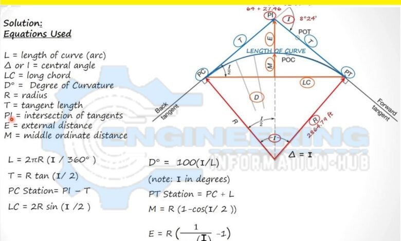
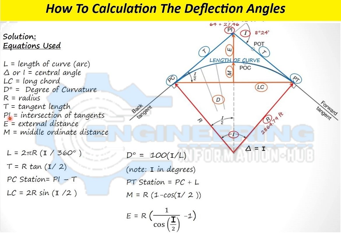
How To Calculation The Deflection Angles
Deflection angle in surveying refers to the angle between two consecutive lines in a survey traverse. It is a crucial concept in land surveying, civil engineering, and construction projects, helping to determine the direction and alignment of various features on the land. This article will delve into deflection angles, their significance in surveying, how they are calculated, and their practical applications. The Deflection Angles How to Calculation The Deflection Angles| How to Calculation The Deflection Angles
What are The Deflection Angles
In surveying, when traversing around a piece of land, surveyors establish a series of straight lines known as traverse legs. At each change in direction between two consecutive traverse legs, a deflection angle is measured. This angle indicates the amount of rotation required to align the next traverse leg with the previous one.

Significance of Deflection Angles
Deflection angles are essential for accurately mapping the boundaries of land parcels, determining property lines, and designing roadways, railways, pipelines, and other infrastructure projects. They help surveyors maintain directional control and ensure that measurements are precise and consistent.
How To Calculation of Deflection Angles
Deflection angles can be calculated using various methods depending on the surveying technique and equipment available. One common approach is the compass rule, where a compass or theodolite is used to measure the angles between traverse legs. Another method involves calculating the interior angles of a traverse and then subtracting them from 180 degrees to obtain the deflection angles.
Practical Applications of Deflection Angles
Boundary Surveys
When surveying property boundaries, deflection angles help determine the direction of boundary lines and identify any discrepancies or encroachments.
Road Design
In highway and roadway design, deflection angles establish the alignment of curves, intersections, and transitions between straight sections and curves.
Construction Layout
During construction, deflection angles guide the layout of buildings, structures, utilities, and other features according to the intended design and alignment.
-
The Layout of Structures in Civil Engineering
-
How to Calculate Distance and Bearing between Coordinates
-
Uses of the Leveling and Principles of Differential Leveling
Pipeline Alignment
In pipeline projects, such as water mains, gas lines, or sewers, deflection angles are crucial for maintaining the desired alignment and gradient along the pipeline route.
Topographic Mapping
Deflection angles aid in creating accurate topographic maps by establishing the direction of contour lines and terrain features.
Deflection angles play a vital role in surveying by determining the direction and alignment of traverse legs. They are fundamental for various applications, including boundary surveys, road design, construction layout, pipeline alignment, and topographic mapping. how to calculate and interpret deflection angles is essential for ensuring the accuracy and reliability of surveying measurements and facilitating successful land development and infrastructure projects.
Related post
-
Land Surveying And Essence of Topographical Survey
-
Introduction And Calculation Of Elevation With Rise Fall Method With Step
-
Surveying And Principles Of Surveying In Civil Engineering